- жµПиІИ: 1741822 жђ°
- жАІеИЂ:

- жЭ•иЗ™: жИРйГљ
-

жЦЗзЂ†еИЖз±ї
- еЕ®йГ®еНЪеЃҐ (520)
- Oracle (10)
- OracleйФЩиѓѓйЫЖ (8)
- OracleеЃЙи£ЕеНЗзЇІ (15)
- OracleжЧ•еЄЄзЃ°зРЖ (51)
- Oracleе≠Чзђ¶йЫЖ (7)
- Oracleе§ЗдїљжБҐе§Н (24)
- OracleдЉШеМЦ (4)
- OracleзЉЦз®Л (52)
- OracleеѓЉеЕ•еѓЉеЗЇ (19)
- OracleдљУз≥їзїУжЮД (15)
- OracleзљСзїЬ (2)
- OracleеЃЙеЕ® (2)
- OracleжЭГйЩР (3)
- OracleжХ∞жНЃе≠ЧеЕЄеТМжАІиГљиІЖеЫЊ (2)
- OracleеЄЄзФ®еЬ∞еЭА (5)
- SQLPLUSдЄУж†П (7)
- SqlServer (13)
- SqlServer2005зЉЦз®Л (27)
- SqlServer2005зЃ°зРЖ (15)
- MySQL (20)
- DoradoеЇФзФ® (1)
- C# (24)
- Arcgis ServerеЉАеПС (20)
- ArcSDEжКАжЬѓ (19)
- UMLе≠¶дє† (2)
- иЃЊиЃ°ж®°еЉП (2)
- JAVA EE (4)
- JavaScript (3)
- OFBIZ (27)
- JAVA WEBеЉАеПС (22)
- Linux&Unix (34)
- SHELLзЉЦз®Л (14)
- Cиѓ≠и®А (11)
- зљСзїЬеНПиЃЃ (14)
- FREEMARKER (2)
- GROOVY (2)
- JAVAиѓ≠и®А (3)
- йШ≤зБЂеҐЩ (0)
- PHP (2)
- Apache (2)
- Loader Runner (1)
- Nginx (3)
- жХ∞жНЃеЇУзРЖиЃЇ (2)
- maven (1)
з§ЊеМЇзЙИеЭЧ
- жИСзЪДиµДиЃѓ ( 0)
- жИСзЪДиЃЇеЭЫ ( 22)
- жИСзЪДйЧЃз≠Ф ( 0)
е≠Шж°£еИЖз±ї
- 2016-04 ( 1)
- 2015-12 ( 2)
- 2015-11 ( 2)
- жЫіе§Ъе≠Шж°£...
жЬАжЦ∞иѓДиЃЇ
-
жАЉжАЉжАЉжАЉпЉЪ
   
oracleзЪДtimestampз±їеЮЛдљњзФ® -
жАЉжАЉжАЉжАЉпЉЪ
    
oracleзЪДtimestampз±їеЮЛдљњзФ® -
жАЉжАЉжАЉжАЉпЉЪ
                   
oracleзЪДtimestampз±їеЮЛдљњзФ® -
pg_guoпЉЪ
жДЯи∞Ґ¬†¬†¬†¬†¬†¬†¬†
oracleдЄ≠жЯ•зЬЛзФ®жИЈжЭГйЩР -
xu234234пЉЪ
5гАБMapResourceManagerжОІдїґдЄ≠жЈїеК†дЇЖдЄ§дЄ™жЬНеК°пЉМ ...
еМЧдЇђArcGis ServerеЇФзФ®еЯЇз°АеЯєиЃ≠зђФиЃ∞1
Each database management system (DBMS) has different rules for using multiple geodatabases. In general, though, it is possible to create separate databases, store a geodatabase in each one, and connect to each one using separate ArcSDE services no matter what DBMS you are using.
Beginning with 9.2, you can also create multiple geodatabases inside one Oracle database. This model for storing multiple geodatabases in one Oracle database is described below. This is followed by sections containing specific information for storing multiple geodatabases using other DBMS types and models.
Multiple geodatabases in one Oracle database
You can create multiple geodatabases in one Oracle database. When you do this, you create a geodatabase in a user's schema. These geodatabases contain their own ArcSDE and geodatabase system tables. There can be only one geodatabase per user schema. Geodatabases in the user's schema run concurrently with one master SDE geodatabase that is stored in the SDE schema.
The geodatabase in the SDE schema is always the master geodatabase and contains a table (SDE.INSTANCES) that keeps track of all the other geodatabases in the Oracle database. The SDE schema also contains the ST_Geometry type as well as its subtypes and functions.
Both the SDE geodatabase and user-schema geodatabases are created under a single Oracle database and can be accessed by a single ArcSDE service. 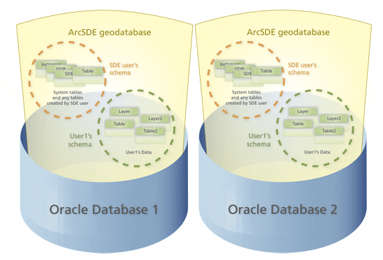  
 
Situations for which you may want to have multiple geodatabases in the same Oracle database include the following:
- If smaller groups within an organization, such as departments or project groups, will work independently of each other, they may want their own data. You could have a geodatabase for each group.
- Separating your development environment from your production environment
- Separately tuning each geodatabase for the specific applications it will service
- Protecting sensitive information
For example, you may want to have a sensitive military database protected in its own geodatabase so owners of other instances will not be able to see the data.
Rules for using multiple geodatabases in one Oracle database
- A user can own only one geodatabase.
- Only one geodatabase can reference a dataset that has been registered with ArcSDE.
- A geodatabase is owned by the user who created it. That user is the ArcSDE administrator user for that geodatabase.
Creating geodatabases in a user's schema in an Oracle database
You create user geodatabases by running the sdesetup command with the install operation. For the instance (the вАУi option), you must specify the port number and the schema. For the user name and password, these must be the user name and password of the user who will own the geodatabase. The following is an example of this:
sdesetup вАУo install вАУd ORACLE10G вАУi 5151:Thor вАУu Thor вАУp rot вАУl license.txt
For the instance option, 5151 is the port number and Thor is the schema, which is also the user name since schemas correspond to user names in Oracle databases.
NOTE: Be sure you specify the schema. If it is not specified and only a port number is provided, the SDE schema will be used by default. Since the geodatabase in the SDE schema already exists, executing the sdesetup вАУo install command will upgrade the SDE geodatabase.
If you are using a direct connection, you still need to specify 5151:<user_schema> with the вАУi option. If doing a remote installation from a Windows machine, you also need to add a 5151 service in the Windows service file of the machine from which you are executing the sdesetup command.
It is recommended you store the system tables that get created with the sdesetup вАУo install command in a different tablespace than the one used for your SDE geodatabase. This will help avoid I/O contention and will allow you to backup the tablespace seperately if needed. To create the system tables of the user-schema geodatabase in a different tablespace, make a copy of your dbtune.sde file, and edit the parameters under the in the dbtune file to point them to a different tablespace. Do this prior to running the sdesetup command to create the geodatabase in a user's schema. For information on the dbtune file and how to alter it, see The dbtune file and the DBTUNE table.
NOTE: The user (in this example, Thor) must be given the same privileges you provide for the SDE user while installing or upgrading the SDE geodatabase.
Registering tables and layers
Users who own geodatabases are allowed to create tables in other geodatabases, but the table can be registered in only one geodatabase.
sdetable вАУo register вАУt tablename вАУi port:schemaname вАУu user вАУp passwd sdelayer вАУo create вАУl tablename,shape вАУi port:schemaname вАУu user вАУp passwd
If the table has already been registered in another schema, the SE_TABLE_REGISTERED_OUTSIDE_SCHEMA error will be returned.
For tables created with Oracle Spatial, you could use autoregistration for table and layer registration. Autoregistration registers as feature classes with the ArcSDE geodatabase any unregistered SDO_GEOMETRY tables. Autoregistration detects unregistered SDO_GEOMETRY tables by comparing the list of feature classes in the LAYERS table with the list of SDO_GEOMETRY tables in the USER_SDO_GEOM_METADATA table whenever a user connects and requests a list of feature classes from the ArcSDE server. To use autoregistration, the server configuration parameter DISABLEAUTOREG in the ArcSDE SERVER_CONFIG table must be set to FALSE.
Each ArcSDE geodatabase has its own LAYERS and SERVER_CONFIG tables. You must separately set to FALSE the DISABLEAUTOREG parameter in the user geodatabase's SERVER_CONFIG table to allow SDO_GEOMETRY tables to be autoregistered in the user's geodatabase.
Managing geodatabases created in user schemas
The user who owns the geodatabase is the ArcSDE administrator. In other words, the user is equivalent to the SDE user in the SDE master geodatabase. In the example geodatabase created above, the user Thor would perform such tasks as compressing or upgrading for the geodatabase Thor owns.
Note that since the geodatabase is in Thor's schema, the DEFAULT version for the geodatabase in the version table is named Thor.DEFAULT.
Starting and stopping a geodatabase in a user's schema
Geodatabases stored in schemas other than the SDE schema are dependent on the SDE geodatabase. Once you start or shut down the SDE geodatabase, all associated geodatabases will automatically be started or shut down. An attempt to start a geodatabase stored in a user's schema independently will result in an error similar to the following:
init_DB DB_instance_open_as_dba: -93
DBMS error code: 1017
ORA-01017: invalid username/password; logon denied
 
Listing the geodatabases present on a server
You can find out what geodatabases are running on a server by using the вАУI option on the sdemon вАУo info command. This option will return information regarding the various geodatabases that are present on a server.
sdemon вАУo info вАУI instances ArcSDE Instance sdeora10g's instances on jupiter at Wed Mar 08 08:23:14 2006 Instance Created Id SDE Thu Oct 28 16:30:20 2004 0 MAP Mon Feb 27 11:18:04 2006 1
 
NOTE: This will not work if you are only using direct connect because you cannot use the sdemon command if no ArcSDE service is running.
For details on the sdemon command, consult the ArcSDE Administration Command Reference installed with ArcSDE.
Creating stored procedures for geodatabases stored in a user's schema
Each geodatabase has its own set of stored procedure packages that are automatically created in the ArcSDE administrator's schema upon geodatabase creation.
In addition, you can create individual packages in the geodatabase through SQL*Plus if you provide the schema name. For example, to create the dbtune_util package in the Thor user schema, issue the following command at the SQL prompt:
@dbtune_util.sps Thor
Creating connections to geodatabases in user's schemas
You can use an ArcSDE service or a direct connection to geodatabases owned by users other than SDE. However, only one giomgr process is used: the one to the SDE geodatabase. There are not separate giomgr processes for each geodatabase.
For ArcSDE service connections, use the port number and the schema as in the example 5151:Thor. (Note that the port number is the same for the SDE geodatabase and user-owned geodatabases.)
To create a direct connection to a user-owned geodatabase, specify the schema name in the connection using this:
sde:oracle10g:/:<schema_name>
If you don't provide a schema name, the SDE schema will be used by default.
NOTE: The forward slash, "/", between Oracle 10g and the schema_name is used in place of the database name, since Oracle does not use one.
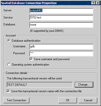
Connecting to a geodatabase in a user's schema from ArcGIS
You can use ArcGIS 9.2 clients to connect to a user-owned geodatabase. You do this by specifying the port and schema (in the format port:schema) for the service name on the Spatial Database Connection Properties dialog box in ArcCatalog.
When you initially make a database connection in ArcCatalog, you are automatically connecting to the sde.DEFAULT version of the geodatabase. To connect to a geodatabase in the schema of a user other than SDE, click the Change button under Connection details on the Spatial Database Connection Properties dialog box and change the version name from sde.DEFAULT to <user_schema>.DEFAULT. In the following example, the schema name is TEST, so the connection would be to TEST.DEFAULT.
For more information on making a spatial database connection, see Creating spatial database connections.
Loading data into a geodatabase
You load data into geodatabases stored in a nonSDE user's schema the same way that you load data into the SDE master geodatabaseвАФwith either ArcCatalog (the recommended method) or ArcSDE commands.
It is important to note that if you are connected to two different geodatabases in the same Oracle database as the same user in ArcCatalog, when you try to copy and paste data between the geodatabases, the paste will fail.
You can load a table into a geodatabase with the same table name that exists in another geodatabase as long as the tables are owned by different schemas.
Creating a backup of a user-owned geodatabase
If all the tables in the geodatabase are owned by the geodatabase owner (in other words, if no other user created data in the geodatabase) and the geodatabase owner does not own data in any other geodatabase, you can create a backup of the geodatabase owner's schema. If users have data spread across multiple geodatabases in the same Oracle database, you would have to perform a complete Oracle system backup and restore.


- 2008-07-03 13:46
- жµПиІИ 3546
- иѓДиЃЇ(0)
- жЯ•зЬЛжЫіе§Ъ
еПСи°®иѓДиЃЇ

-
SDEзФ®жИЈжЭГйЩРиДЪжЬђ
2008-07-14 13:44 3459DROP ROLE SDE_UPGRADE;CREATE RO ... -
ArcSDE/OracleзЪДзЃАеНХдЉШеМЦ(еЫЊе±ВеТМ糥еЉХеИЖеЉА)
2008-07-10 10:01 27191.SDEзЪДжАІиГљдЄїи¶БињШжШѓеПЦеЖ≥дЇОOracleзЪДжАІиГљпЉМзДґеРОжЙНжШѓSD ... -
ArcSDEзЪДзЙИжЬђзЃ°зРЖжЬЇеИґ
2008-07-07 15:10 2653зЙИжЬђжШѓSDEжХ∞жНЃеЇУдЄ≠зЃ°зРЖжХ∞жНЃзЪДдЄАзІНжЬЇеИґпЉМдЄїи¶БиІ£еЖ≥йХњдЇЛеК°йЧЃйҐШгАВ ... -
ArcSDEж†Еж†ЉжХ∞жНЃзЪДе≠ШеВ®зїУжЮД
2008-07-07 13:19 2231дЄАдЄ™еЕГжХ∞жНЃи°®пЉЪSDE_raster_columns дЄАдЄ™дЄЪеК° ... -
Raster dataset schema overview
2008-07-07 10:51 12991гАБBusiness table 2гАБAUX table:St ... -
еЄЄзФ®еСљдї§
2008-07-07 10:41 13881гАБsdetable жЯ•зЬЛи°®зЪДеЕ≥з≥ї ¬†¬†¬†¬† eg. sdet ... -
Manage vector storage
2008-07-07 10:32 1335дЄАгАБеИЫеїЇи°®з©ЇйЧіcreate tablespace gis_da ... -
Manage raster storage
2008-07-07 09:37 1023дЄАгАБеИЫеїЇи°®з©ЇйЧіcreate tablespace versio ... -
SDEдЄ≠зЪДи°®
2008-07-04 09:25 24251гАБBи°®пЉЪе±ЮжАІи°® 2гАБFи°®пЉЪи¶Бзі†и°® 3гАБSи°®пЉЪ糥еЉХи°® 4гАБAи°® ... -
SDEдЄЙзІНињЮжО•жЦєеЉП
2008-07-03 14:57 2592дЄАгАБApplication server connection ... -
Operating multiple geodatabases
2008-07-03 14:15 1392Creating multiple geodatabases ... -
еЯЇдЇОGeodatabaseжХ∞жНЃж®°еЮЛзЪДзЙИжЬђжЬЇеИґ
2008-07-03 11:32 1657дЄАгАБзЙИжЬђжШѓдїАдєИпЉЯпЉИWhat is Version?пЉЙ вАЬзЙИжЬђвАЭ ... -
arcsde9.2еТМoracleеИЖеЄГеЉПеЃЙи£Е
2008-07-02 11:18 2654зОѓеҐГпЉЪ oracle10gR2еЃЙи£ЕеЬ®дЄ§еП∞жЬНеК°еЩ®дЄКпЉМдљЖеП™жШѓеБЪеПМжЬЇ ... -
еИЫеїЇе§ЪдЄ™ArcSDEеЃЮдЊЛ
2008-07-02 09:29 2663жЬЙжЧґеАЩпЉМжИСдїђйЬАи¶БжЬЙе§ЪдЇОдЄАдЄ™зЪДArcSDEеЃЮдЊЛеРМжЧґињРи°МгАВеП™и¶Бе≠ШеЬ® ... -
SDEеСљдї§и°МеЃЙи£ЕйЕНзљЃ
2008-07-01 16:34 3351дЄАгАБеИЫеїЇзЫЄеЕ≥и°®з©ЇйЧі еИЫеїЇsdeи°®з©ЇйЧі create table ... -
oracle for sdeйЕНзљЃ
2008-06-30 15:40 21261гАБдњЃжФєoracleз≥їзїЯеПВжХ∞alter system set ... -
ArcSDEз©ЇйЧіжХ∞жНЃеЇУдЄ≠SDEзФ®жИЈдљњзФ®жОҐиЃ®
2008-06-30 15:26 3019ArcSDEдљЬдЄЇз©ЇйЧіжХ∞жНЃеЇУиІ£еЖ≥жЦєж°ИпЉМеЇФзФ®йЭЮеЄЄеєњж≥ЫпЉМжЬђзЯ≠жЦЗе∞Же∞ЭиѓХ ... -
еИЫеїЇе§ЪдЄ™ArcSDEеЃЮдЊЛ
2008-06-23 19:42 2066жЬЙжЧґеАЩпЉМжИСдїђйЬАи¶БжЬЙе§Ъд ...
зЫЄеЕ≥жО®иНР
Designing_Geodatabases_With_Visio
Step by step,жХЩдљ†е¶ВдљХеИЫеїЇдЄАдЄ™geodatabaseпЉМжЙАзФ®еЬ∞еЫЊиµДжЦЩдЄЇarcgisиЗ™еЄ¶гАВ
arcsde з©ЇйЧіжХ∞жНЃеЇУжХЩз®ЛпЉМзЃ°зРЖеСШжЙЛеЖМгАВ е≠ЧжХ∞и°•дЄБгАВ
еИ©зФ®visio зФЯжИРgeodatabase еЊИе•љзЪДжХЩз®Л пЉМдЄНињЗйЗМйЭҐжЬЙbug жИСеЬ® еНЪеЃҐдЄ≠ иѓ¶зїЖиІ£еЖ≥дЇЖињЩдЇЫйЧЃйҐШ
Chapter 7, Geoprocessing with Geodatabases, shows the readers how to use Spatial SQL to perform geoprocessing with database tables containing a spatial column. Chapter 8, Automating QGIS Analysis, ...
жШѓдЄАжЬђеЯЇдЇОARCGISзЪДpythonе≠¶дє†дє¶з±НпЉМARCGISжШѓзФ®еЬ∞еЬ∞зРЖз©ЇйЧіжХ∞жНЃе§ДзРЖгАВ
Access the spatial data contained within shapefiles and geodatabases, for updates, analysis and even transformation between spatial reference systems Produce map books and automate the mapping of ...
Brief Overview of Geodatabases Goals of the Exercise Computer and Data Requirements Procedure: 1. Creating a Geodatabase 2. Creating a Feature Class 3. Creating a Feature Dataset 4. Exporting a ...
3. Using tools 4. Batch processing 5. Messaging and script tools 6. Data properties and access 7. Working with geodatabases еЕґдЄ≠зђђдЇМзЂ†еЉАеІЛпЉМжШѓиѓ¶зїЖиЃ≤ињ∞pythonзЪДпЉМйАВеРИеИЭе≠¶иАЕпЉМињШжЬЙиЗ™е≠¶зЪДдЇЇпЉМиЩљзДґжШѓиЛ±жЦЗ...
Appendix A: Reading the object model diagrams Appendix B: ArcGIS developer resources Appendix C: Converting personal geodatabases Appendix D: Installing ArcGIS Engine Runtime on Windows, Solaris, ...
ArcGISжУНдљЬеЯЇдЇОGISжЦЗдїґж†ЉеЉПеТМе≠ШеВ®дЇОgeodatabasesдЄ≠зЪДеЬ∞зРЖдњ°жБѓгАВGeodatabaseжШѓArcGISзЪДжЬђеЬ∞жХ∞жНЃзїУжЮДпЉМжШѓзФ®дЇОзЉЦиЊСеТМжХ∞жНЃзЃ°зРЖзЪДеЯЇжЬђжХ∞жНЃж†ЉеЉПгАВ
he ArcSDE Developer Help system explains ArcSDE concepts, provides access to C and Java API References that work with ArcSDE geodatabases, and also provides samples for you to get started with ...
ArcCatalogиГље§ЯиѓЖеИЂдЄНеРМзЪДGISжХ∞жНЃйЫЖпЉМе¶ВArcInfo coveragesгАБESRI shapefilesгАБgeodatabasesгАБINFOи°®гАБеЫЊеГПгАБgridгАБTINгАБCADжЦЗдїґгАБеЬ∞еЭАи°®гАБеК®жАБеИЖжЃµдЇЛдїґи°®гАБеПКеЕґдїЦзЪДESRIжХ∞жНЃз±їеЮЛеТМжЦЗдїґгАВжѓПдЄАзІНжХ∞жНЃйЫЖйГљзФ®дЄАдЄ™еФѓдЄАзЪД...
3D Analyst\Animation\Carto \Visual JavaBeans \File Data Sources \Geodatabase Data Sources \NetCDF Data Sources \Object Linking and ...Analyst \Distributed Geodatabases \Geodatabase Extensions \...
OldskoolпЉЪ пЉЪ//desktop.arcgis.com/en/arcmap/10.7/manage-data/gdbs-in-oracle/overview-geodatabases-oracle.htm и¶Бж±В еЈ≤еЃЙи£ЕArcGIS ProпЉИеН≥Python 3+пЉЙ жЭ•иЗ™ж≠§иЃ°зЃЧжЬЇзЪДжХ∞жНЃеЇУињЮжО•пЉИдЊЛе¶В64дљН19c OracleеЃҐжИЈзЂѓпЉЙ...
е∞ЖGeoDatabasesеТМзФ®дљЬвАЬжЬђжЬЇвАЭ DataFrameжЇРгАВ еИЫеїЇи¶БеЬ®ScalaпЉМPythonеТМRдЄ≠дљњзФ®зЪДз©ЇйЧізФ®жИЈеЃЪдєЙз±їеЮЛгАВ еИЫеїЇи¶БеЬ®ScalaеТМPythonдЄ≠дљњзФ®зЪДз©ЇйЧізФ®жИЈеЃЪдєЙеЗљжХ∞гАВ ељ±еУНз©ЇйЧіињЮжО•жߕ胥зЪДпЉМдљњеЊЧеЯЇдЇОиЊУеЕ•жХ∞жНЃйАВељУеЬ∞йАЙжЛ©еЬ∞еЫЊдЊІ...